

KATHMANDU - SOTI KHOLA - DOBHAN - CHUMLING - NILE - GUMBA LUNGDANG - SAMA - BIMTHANG - DHARAPANI


Why Budget Manaslu and Tsum Valley Trek?
- Alternative trekking route in Manaslu trekking to avoid the crowds,
- Trekking in a restricted area to experience natural beauty,
- Immersing yourself in the rich and fascinating Tibetan culture and traditions,
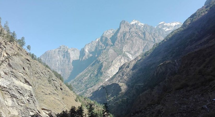
- Stunning scenery and landscapes with towering mountains,
- Climbing to the top of Larka La Pass (5,160 m) for breathtaking views,
- Discovering the unique flora and fauna of the region,
- Exploring the sacred Himalayan region,
- Observing the traditional lifestyle of the local people,
- Visiting remote villages and experiencing the hospitality of the locals,
- Capturing memories of the culture and superstitions of the mountain communities.
The Manaslu and Tsum Valley trek is one of Nepal’s most captivating and lesser-known trekking adventures, offering a perfect blend of natural beauty, cultural richness, and challenging high-altitude trekking. Located in the remote western region of Nepal, this trek takes you around Mount Manaslu, the eighth-highest peak in the world at 8,163 meters, through pristine landscapes and isolated traditional villages rarely touched by mass tourism.
This trek remains less crowded because the region is designated as a restricted area. Trekkers must obtain special permits, such as the Manaslu Restricted Area Permit and the Tsum Valley permit,t to enter and explore. These restrictions help preserve the environment and cultural heritage, making your journey here a rare and authentic Himalayan experience. The permits are usually arranged through a registered trekking agency or by hiring an independent guide experienced with the local regulations and terrain.
The route offers a spectacular variety of scenery, ranging from lush subtropical forests to alpine meadows and high mountain passes. One of the main highlights is the crossing of the Manaslu Larke Pass at 5,160 meters, a challenging but rewarding trekker’s milestone. Crossing this pass demands good physical preparation, proper acclimatization, and guidance from an experienced Manaslu guide to ensure safety. From the pass, panoramic views of towering peaks and deep valleys unfold, making the effort worthwhile.
As you journey through the Manaslu region, you will pass through charming villages inhabited by diverse ethnic groups, including the Gurung, Rai, Magar, and Limbu communities. Their vibrant culture shines through in their traditional clothing, rituals, festivals, and warm hospitality. The trail is also dotted with Buddhist prayer flags, mani walls, stupas, and ancient monasteries, reflecting the deep Tibetan Buddhist influence that enriches the spiritual atmosphere of the region.
The hidden gem within this trek is the Tsum Valley, a sacred Himalayan valley that has remained culturally and ecologically preserved for centuries. Tsum Valley is famous for its religious sites, including remote gompas (monasteries), meditation caves, and local legends steeped in Buddhist mythology. This valley offers trekkers a unique glimpse into a way of life untouched by modern influences, making it a profound cultural highlight of the trek.
Accommodation on the Manaslu and Tsum Valley trek is typically in basic teahouses or lodges run by local families. While facilities are simple, they offer comfort and an authentic experience. Meals usually consist of traditional Nepali and Tibetan dishes such as Dal Bhat, vegetable curries, momos, and Tibetan bread, providing nourishing fuel for your trek. Because the region is remote, food and lodging costs in places like the Tsum Valley may be slightly higher, but overall, the trek remains budget-friendly.
Regarding the Manaslu and Tsum Valley trek cost, it is generally lower than other popular trekking routes in Nepal, especially when booked with a local agency or arranged independently with a guide. Hiring a knowledgeable Manaslu guide is strongly recommended for safety, navigation, cultural interpretation, and assistance with permits and logistics.
In summary, the Manaslu and Tsum Valley trek offers a breathtaking Himalayan adventure for trekkers who want to explore a less-traveled route with stunning mountain views, rich cultural encounters, and a chance to cross the impressive Manaslu Larke Pass. With proper preparation, the right permits, and a reliable guide, this trek is an unforgettable journey into one of Nepal’s most beautiful and culturally significant regions.
Accommodation and meals During the Budget Manaslu and Tsum Valley Trek:
During the Budget Manaslu and Tsum Valley trek, accommodation is primarily in simple, locally-run teahouses or guesthouses that provide basic but comfortable lodging. Facilities typically include a clean bed, shared bathrooms, and sometimes a hot shower (often for an extra charge). Meals are hearty and designed to refuel trekkers, featuring traditional Nepali dishes such as Dal Bhat (lentils and rice), vegetable curry, and momos (Tibetan-style dumplings). You can also enjoy Tibetan specialties like tsampa (roasted barley flour), thukpa (noodle soup), and butter tea. While options may be limited in remote areas like Tsum Valley, the food is generally wholesome and satisfying, supporting your energy for the trek.
Manaslu and Tsum Valley trek weather
Spring Weather (March – May)
Spring brings mild and comfortable temperatures to the Manaslu and Tsum Valley region. Daytime temperatures gradually warm, making trekking enjoyable. Rhododendron forests burst into vibrant bloom, adding color to the trail. While mostly clear skies offer stunning mountain views, occasional rain showers may occur, especially toward late spring. Snow at higher elevations begins to melt, easing passage over mountain passes.
Autumn Weather (September – November)
Autumn is the most favored trekking season due to its cool, dry, and stable weather conditions. Skies are generally clear, providing excellent visibility of Mount Manaslu and the surrounding peaks. Day temperatures are pleasant, but nights can be cold, particularly above 3,000 meters. The dry atmosphere and fresh air create ideal trekking conditions for both comfort and safety.
Budget Manaslu and Tsum Valley Trek Outline
DAY 01: Drive from Kathmandu to Soti khola 710 m/ 2330 ft (0.71 km) km, 7-8 Hour Drive,
DAY 02: Trekking from Soti Khola — Machha Khola 890 m/2,920 ft (0.89 km): 14 km,(6-7 hrs)
DAY 03: Machha Khola — Dobhan 1,000 m/3,280 ft (ca. 1 km):11 km,-6-7 Hrs.
DAY 04: Dobhan — Philim 1,590 m/5,216 ft (1.59 km): 10 km,(6-7 Hrs)
DAY 05:Philim — Lokpa 2,240 m/7,350 ft (2.24 km) — Chumling 2,360 m/7,750 ft (2.36 km)- 6-7 Hrs
DAY 06:Trek from Chumling — Chhekampar 3,010 m/9,850 ft (ca. 3 km): 10 km-5-6 Hrs.
DAY 07: Chhekampar — Nile 3,480 m/11,415 ft (3.48 km): 8 km,-4-5 Hrs
DAY 08: Exploring day, Nile to Mu Gompa 3,709 m/12,169 ft (3.71 km) — Chhekampar 3,010 m/9,870 ft (ca. 3 km): 13 Km,-6-7 Hrs
DAY 09: Chhekampar — Gumba Lungdang 3,200 m/10,496 ft (3.2 km): 12 km,- 5-6 Hrs
DAY 10:Trek from Gumba Lungdang — Ripchet 2,470 m/8,100 ft (2.47 km) — Lokpa 2,240 m/7,348 ft (2.24 km): 14 km,(7 to 8 Hrs )
DAY 11: Trek from Lokpo to New Bridge 1675 m/ 5500 ft (1.68 km): 9 km, 6 to 7 hrs walk,
DAY 12: Trek from Bihi Phedi to Namrung 2,660 m/8,727 ft (2.66 km): 8 km,(5Hrs)
DAY 13: Namrung — Lho 3,180 m/10,430 ft (3.18 km): 4 km, 3-4 hrs to walk,
DAY 14: Trek from Lho to Sama Gaon 3,530 m/11,578 ft (3.53 km) — 8 km, 5-6 hrs,
Day 15: Exploration day: Visit Birendra Tal / Pungyen Gompa / Manaslu Base Camp
3 to 5 hrs
DAY 16: Trek from Sama — Samdo 3,860 m/12,660 ft (ca. 4 km) - 8 km, 4 hrs to walk,
Day 17: Trek from Samdo the Larkya Phedi/Dharamsala 4,460 m/14,628 ft (4.46 km) - 7 km, 3-5 hrs
DAY 18: Dharamsala to Bimthang 3,720 m/12,201 ft (3.72 km) via Larkya La 5,160 m/16,930 ft (ca. 5 km)- 12 km, 7-9 hrs to walk,
DAY 19: Trek from Bimthang the Gho 2,515 m/8,250 ft (2.51 km) — 12 km, 5-6 hrs,
DAY 20: Trek from Gho to Dharapani 1,920 m/6,300 ft (ca. 2 km): 8 km,
DAY 21: Dharapani to Kathmandu 1,300 m/4,264 ft (1.3 km) via Besi Sahar 760 m/2,495 ft (0.76 km): 190 km 8 hrs,
What's included?
- Manaslu Restricted Area Permit and Tsum Valley Permit
- Bus transfer from Kathmandu to Soti Khola and return
- Tea house or lodge accommodation during the trek
- Meals (breakfast in Kathmandu, breakfast, lunch, and dinner during the trek)
- Experienced, licensed Manaslu trekking guide who speaks English
- Porters (s) to carry luggage (one porter for every two trekkers)
- Salaries, insurance, food, and accommodation for the guide and porter
- First aid kit carried by the guide
- Assistance with emergency evacuation if needed
- Communication equipment for emergencies
- Help with trekking permits and paperwork
- Cultural visits to monasteries, gompas, and local villages
- Explanation of the local culture and environment by the guide
What's not included?
- Your Lunch & Dinner in Kathmandu,
- Your travel insurance,
- Emergency rescue operation,
- International flight,
- Departure tax,
- Personal expense,
- Nepal entry visa fee,
- Bar bills,
- All the alcoholic and non-alcoholic Drinks,
- Tip for Guide & Porter,
Day by Day Itinerary
DAY
01:
Drive from Kathmandu to Soti khola 710 m/ 2330 ft (0.71 km)Via- Arughat 6,70 m/2198 ft (0.67 km): 135 km, 7-8 Hour Drive,
5 to 6 Hrs Drive Breakfast, Lunch & Dinner Tea House
Today, you will embark on an unforgettable off-road journey, winding through the majestic mountains and rivers. The drive from Kathmandu to Aarughat will take approximately 5 hours, offering incredible views of typical villages, farmlands, rivers, bridges, and the beautiful Manaslu mountain range. Once you arrive at Aarughat, you will take a short drive along the Budi Gandaki river to Sotighola, where you will stay the night in a tea house or lodge. Your meals - dinner and breakfast - will be provided by the same tea house.
DAY
02
Trekking from Soti Khola — Machha Khola 890 m/2,920 ft (0.89 km): 14 km,
, 6-7 hours Breakfast, Lunch & Dinner Tea House
The trek from Soti Khola to Machha Khola is a distance of 14 kilometers, with a total elevation gain of 890 meters. The trail is mostly flat, with some gradual climbs as you ascend towards Machha Khola. Along the way, you will pass through several villages, terraced farmlands, and impressive mountain views. You can expect to take around 5-6 hours to complete the trek.
DAY
03:
Machha Khola — Dobhan 1,000 m/3,280 ft (ca. 1 km):11 km,
6-7 Hrs Breakfast, Lunch & Dinner Tea House
We will start the trek after having an early breakfast. On the first day, we will follow the river and experience some climbs and descents. The trail will mostly lead us to the gravel bar just before reaching Thado Khola and then to Khorlabesi. Khorlabesi is a well-known village that grows and sells buckwheat, tobacco, and coffee. It is also a junction where the trail from Gorkha joins the trail that leads to the east of Mt. Manaslu towards Langtang, Everest, and Arun valley.
The trekking trail then enters a narrow and lush green gorge. After some walking, you will reach a massive landslide area with a small trail that leads to the hot spring known as Tatopani. From Tatopani, the trekking route goes straight up to the ridge and crosses the Budi Gandaki River. The trail then follows the staircase that leads up to the landslide area and the final climb to reach Dobhan. You will stay overnight in Dovan.
DAY
04:
Dobhan — Philim 1,590 m/5,216 ft (1.59 km): 10 km,
6-7 Hrs Breakfast, Lunch & Dinner Tea House
Today, we will depart from Dobhan Khola and head towards the east bank of the Budi Gandaki River to Thulo Dunga. We will follow the wide valley and riverbank towards Yaruphant, crossing an old bridge as we pass through the village. Our trek will then take us to Thado Bharyang on the west bank of the Budi Gandaki River before continuing beyond the valley to Jagat. This is where you will need to check in your permit for further trekking on the Manaslu route.
From Jagat, we will follow the cliff-side trail and cross streams to reach Salleri, where you will have a great view of the Massif Shringi Himal to the north. The trek then steeply descends to Sirdibas before crossing a suspension bridge and making the final climb for the day to Philim. We will stay overnight in this traditional village, where you can visit the Chholing Sandu Gompa and the picturesque farming fields.
DAY
05:
Philim — Lokpa 2,240 m/7,350 ft (2.24 km) — Chumling 2,360 m/7,750 ft (2.36 km): -10 km,
6-7 Hrs Breakfast, Lunch & Dinner Tea House
Today, we will cross the north side of Philim village and follow the trail through grasslands to a narrow valley and on to Chisapani. After Chisapani and Eklebhatti, we will continue our trek to a lower place and witness stunning waterfalls through the deep gorge before reaching the New Bridge. From there, the trail leads to Larke La.
When trekking to the right east side from the New Bridge, the trail will take a zigzag path through the blue pine and rhododendron forest before reaching Lokpa. After a short walk, we will arrive at Tsum Valley, a mixed traditional village where approximately 4000 people reside.
We will then follow the trail to Siyar Khola after descending through the forest, streams, and steep staircase trail. After climbing the south part of Siyar Khola, you will reach the spectacular Tsum Valley. The top ridge is adorned with many prayer flags and you will descend to the stream, cross it, and make the ascent to Chumling village, a traditional village with classic houses with sloped roof tops. You will stay in Chumling overnight.
DAY
06:
Trek from Chumling — Chhekampar 3,010 m/9,850 ft (ca. 3 km): 10 km,
5-6 Hrs. Breakfast, Lunch & Dinner
Today's trek starts with a crossing of a suspension bridge, leading into the forest and through a landslide area. The trail mostly winds through dense forest and stunning wilderness, with the first part showcasing a small water-powered prayer wheel. The journey continues to Tanju via a monastery and then on to Dumje, offering stunning views of the Ganesh Himal and Baudha Peak.
As you descend Sharphu Khola, the Syakpa Glacier of Shringi Mountain comes into view. The trail then leads up the hill to Gho in the upper Tsum Valley. The breathtaking beauty of the area and towering snow-capped mountains will keep you motivated, leading to a short walk to Chhokang Paro and Chhekampar, known as a place of wisdom. Chhekampar is a breathtakingly beautiful village, with well-maintained farmland growing crops such as corn, buckwheat, potatoes, barley, and vegetables. You will spend the night at a tea house in Chhekampar.
DAY
07:
Chhekampar — Nile 3,480 m/11,415 ft (3.48 km): 8 km,
4-5 Hrs Breakfast, Lunch & Dinner Tea House
From Chhekampar, we walk along the village school at Kaye and continue on a gradual trail to Leru and Ngakyu. After passing by the Rachen Nunnery near the river, the trail descends slightly to the ridge and goes through several Buddhist chortains before reaching Lama Gaon.
Today's route is relatively easy and consists mostly of a downhill trail, passing Buddhist chortains, caves, and lush forests. Along the way, you'll see sights like the Burja village, Milarepa cave, footprints of Milarepa, and an elephant-shaped stone, all while taking in the breathtaking mountain views. You will spend the night in Nile.
DAY
08:
Exploring day, Nile to Mu Gompa 3,709 m/12,169 ft (3.71 km) — Chhekampar 3,010 m/9,870 ft (ca. 3 km): 13 Km,
6-7 Hrs Breakfast, Lunch & Dinner Tea House
Begin your journey early in the morning and hike towards the ancient Mu Gompa. The next few hours of the trek will take you to the even older Dephyu Doma Nunnery, which was built 856 years ago and is situated atop a slope at an elevation of 4000 meters.
Once you reach the top of the Old Gompa, you will be rewarded with a breathtaking view of Ganesh Himal II. After admiring the view, return to Nile for a lunch break before continuing your trek to Chhekampar. Spend the night in Chhekampar.
DAY
09:
Chhekampar — Gumba Lungdang 3,200 m/10,496 ft (3.2 km): 12 km,
, 5-6 Hrs Breakfast, lunch & Dinner
Starting from the bridge, we follow the trail to Dumje, known for its Tibetan medicinal school. The journey to Gumba Lungdang is a steep, 3.5-hour trek through a dense forest of Rhododendron, oak, and pine. Along the way, the stunning wilderness will amaze you.
Upon reaching Gumba Lungdang, you will have the opportunity to visit the 110-year-old gompa where 20 nuns reside. If interested, you may be able to spend the night in the gompa, sleeping on the balcony, although access is not guaranteed for all visitors.
DAY
10:
Trek from Gumba Lungdang — Ripchet 2,470 m/8,100 ft (2.47 km) — Lokpa 2,240 m/7,348 ft (2.24 km): 14 km,
7 to 8 Hrs Breakfast, Lunch & Dinner Tea House
We begin our trek by heading downhill to Dumje, crossing the Sagdang Khola stream. From there, we follow the trail on the south bank and continue to Siyar Khola. There are two trails available, we take the lower one, which takes us through a steep descent into the gorge and then up to the fertile village of Ribbon Gaon (Ripchet).
As we continue our trek, we pass by stunning landscapes and forests, as well as Buddhist chortens and fields of crops like buckwheat and potatoes. We make our way to Gumlung and then Lokpo before heading back down to Dumje. The lower trail offers breathtaking views of the gorges as we cross them on newly built bridges.
DAY
11:
Trek from Lokpo to New Bridge 1675 m/ 5500 ft (1.68 km): 9 km, 6 to 7 hrs walks,
6-7 Hrs Breakfast, Lunch & Dinner Tea House
At Lokpa, there's a junction where the trail meets up with Philim. We must cross the Budi Gandaki River, then navigate the narrow gorge, crossing the river once more to enter a forest of beautiful bamboo, before reaching Deng (1,800 m).
Deng is a well-known gateway to Kutang and Nupri and is home to the Gurung people, who practice Tibetan Buddhism and have their own unique culture, language, and trade route to Tibet. After this charming village, the trek continues to Rana, crossing a log bridge over a small stream, before descending to Bihi Phedi.
The trail moves to the east bank and takes a zigzag path upward to Rana. Then, a set of steep switchbacks leads to a log bridge over a tributary and a secluded water mill, before the trail gradually descends to the lodge at Bihi Phedi, located high above the river.
DAY
12:
Trek from Bihi Phedi to Namrung 2,660 m/8,727 ft (2.66 km): 8 km,
5 Hrs to Walk Breakfast, Lunch & Dinner Tea House
From Bihi, the trail starts by climbing along the river. Then, it descends to the Serang Khola stream and continues through basalt walls, rocks, and waterfalls. After crossing these obstacles, the trail leads northeast and crosses bridges, taking you to Ghap (2250 m).
As you reach Ghap, the trail becomes steep and takes you through forests of Rhododendron, Bamboo, Oak, and Fir. You then cross the north river bank and cross back to the south bank over a wooden bridge. The trail continues to climb steeply for about 1 hour until you reach Namrung, where you must check your trekking permit at the entrance of the village.
DAY
13:
Namrung — Lho 3,180 m/10,430 ft (3.18 km): 4 km, 3-4 hrs to walk,
3-4 Hrs to Walk Breakfast, Lunch & Dinner Tea House
After a nutritious breakfast at the lodge, your trek takes you through a lush forest filled with diverse vegetation and breathtaking landscapes. The destination for today is Lihi, a Tibetan inhabited area known for its unique culture, traditions and festivals.
As you make your way towards Lho, the view is simply breathtaking with the majestic Ganesh Himal in the east and Himlachuli in the south, along with numerous other peaks and breathtaking scenery.
The trail descends to a lower altitude before entering a small valley, where you cross the Hinang Khola. From here, the trail also leads to the Himal Chuli base camp. The trek continues to Sho (2960m) with an awe-inspiring view of the surroundings, including numerous prayer wheels along the trail. The trail then steeply ascends to Shrip, with an overnight stay at Lho, where you can enjoy a captivating sunset view of Manaslu, the 8th highest peak in the world.
DAY
14:
Trek from Lho to Sama Gaon 3,530 m/11,578 ft (3.53 km) — 8 km, 5-6 hrs,
5-6 Hrs. Breakfast, Lunch & Dinner Tea House
After a breakfast, the trek continues through the forest and reaches the village of Lho, a high-altitude settlement inhabited by Tibetan people who have their own language, culture, and festivals. From Lho, the stunning panoramic view of the Ganesh Himal in the east and Himlachuli in the south, along with other peaks and landscapes, is simply breathtaking.
The trail then descends to the Damonan Khola and smoothly passes through the forest to reach Shayla, a plateau at 3,520 meters with a magical view of 180-degree landscapes including the Mount Manaslu, Ngadi Chuli, Himal Chuli, and many snow-capped peaks and glaciers.
The route crosses the Numla Khola bridge, leading to Pungyen Glacier and Pungyen Gompa, walking past a school and a large Buddhist Chorten in the broad valley. After a few hours of trekking, the trail reaches Sama Gaon, with a clear view of the Manaslu and Naike peaks. The Kargyu Chholing Monastery stands at the far end of the village, surrounded by a forested moraine.
DAY
15
Exploration day: Visit Birendra Tal / Pungyen Gompa / Manaslu Base Camp
3 to 5 hrs Breakfast, Lunch & Dinner Lodge
Today, you have the opportunity to explore the region and experience some of the best trekking moments of your trip. You can take a break and venture out with a small day pack to visit two main attractions: Manaslu Base Camp and Birendra Tal.
The village of Nupri is the center of traditional architecture and culture, where you can learn about their old customs and witness farming practices such as potato and barley cultivation, as well as wool production from sheep and goats.
One of the highlights is a visit to the ancient monastery, over 500 years old, which showcases unique and captivating paintings. Afterwards, you can hike to Birendra Tal (3450 m), located just below the Manaslu Glacier for breathtaking views.
For those who are more interested in exploring the base of Manaslu, there is a trail leading from Samdo, after crossing a bridge, that takes you on a steep climb to the hilltop and the Manaslu Base Camp. However, this is a relatively long trek, so it's suggested to only attempt it if you are physically fit. If not, you can still explore the cultural area and visit the gompas.
DAY
16
Trek from Sama — Samdo 3,860 m/12,660 ft (ca. 4 km) — 8 km, 4 hrs to walk,
4 Hrs to Walk Breakfast, lunch & Dinner Lodge
From Sama, you will trek down to the Budi Gandaki River and cross a beautiful lake and several Mani walls. The trail is relatively easy and goes through a Birch and juniper forest surrounded by Kermo Kharka. You'll also come across a large stone wall that separates the villages of Sama and Samdo.
After reaching the Budi Gandaki River again, you will cross it via a wooden bridge, then begin a steep ascent to the convergence of the river with the Mayol Khola, located to the northwest of the Samdo Glacier.
Once you reach the top of the hill, you will find a rocky area with some farmland before arriving at the picturesque Samdo village. This region is a popular spot for summer grazing, as well as for yak and goat herding.
As you continue along the zigzag trail, adorned with flags, you will have a chance to get an up-close view of the majestic Samdo Peak (6,335 m) and the mysterious glacier to the east. Samdo is the last village before Gho in the Manag district and is a unique and naturally stunning place, full of interesting attractions and cultural heritage.
DAY
17
Trek frok Samdo the Larkya Phedi/Dharamsala 4,460 m/14,628 ft (4.46 km) — 7 km, 3-5 hrs to walk,
3-5 Hrs to Walk Breakfast, Lunch & Dinner Basic Tea House at Dharmasala
Today's trek begins with a steep descent to the Budi Gandaki River and continues through the lush forests of the westward trail towards the Syacha Khola valley. The trail then ascends gradually to the Larkya Glacier past the Phedi of Larkya La, also known as Dharmasala.
Dharmasala is a remote area with limited stone-structured tea houses. During peak trekking season, it may be necessary to stay in a shared tent as there may not be enough tea houses. Despite its remote location, the view from Dharmasala is breathtaking, especially the towering peaks of Larke (6,249 m) and Naike (6,291 m).
DAY
18
Dharamsala to Bimthang 3,720 m/12,201 ft (3.72 km) via Larkya La 5,160 m/16,930 ft (ca. 5 km)- 12 km, 7-9 hrs to walk,
7-9 Hrs to Walk Breakfast, Lunch & Dinner Tea House
Today marks a defining moment in your trekking journey as you make your ascent to the summit of Larkya La Pass. Standing at an altitude of over 5,100 meters, this pass presents a formidable challenge with its steep incline and potential for snow-covered trails.
Starting from the remote Dharmasala, the trail to the top of Larkya La rises steadily, making it a long but rewarding journey. On the way, you'll encounter several points adorned with colorful Buddhist prayer flags, and eventually reach the summit where you can sit and take in breathtaking views of both the Annapurna and Manaslu mountain ranges.
The descent from the summit to Bhimtang is steep, but the views of the snow-capped mountains along the way are sure to leave a lasting impression. Bhimtang, a local village surrounded by natural beauty, serves as the perfect place to rest and reflect on the day's journey.
DAY
19
Trek from Bimthang the Gho 2,515 m/8,250 ft (2.51 km) — 12 km, 5-6 hrs,
5-6 Hrs Breakfast, Lunch & Dinner Tea House
Today's trek starts with a descent of approximately 1200 meters, passing through the Bhimtang village. The trail then drops to the glacier and continues over the moraine, through a beautiful forest. The views in the background are breathtaking, featuring peaks such as Manaslu, Nadi, Himal Chuli, and more.
Next, the trail descends towards the west bank of the Dudh Khola river, and you'll follow a small trail down to the village of Karche (2,700 meters). After passing through landslides, farming fields, and a short climb to a ridge, a short walk takes you to the picturesque village of Gho.
DAY
20
Trek from Gho to Dharapani 1,920 m/6,300 ft (ca. 2 km): 8 km,
3-4 Hrs to Walk Breakfast, Lunch & Dinner Lodge
After breakfast, we embark on the final stretch of our budget Manaslu trek. We start by passing through terrace fields and local farmlands to reach Tilje village (2,300 m). Then, we cross the east bank of the river and descend steeply to the Marsyangdi river valley. After making our way to Thoje, we cross the Marsyangdi river and arrive at the junction of Annapurna circuit and Manaslu region in Dharapani.
This marks the end of our trek, and we can spend some time exploring the charming village of Dharapani. A refreshing shower is the perfect way to celebrate the successful completion of our journey.
DAY
21
Dharapani to Kathmandu 1,300 m/4,264 ft (1.3 km) via Besi Sahar 760 m/2,495 ft (0.76 km): 190 km 8 hrs,
8 Hrs Breakfast, Lunch & Dinner Kathmandu Hotel
After your last day of trekking in Dharapani, it's time to head back to Kathmandu. The journey is 190 km long and takes around 8 hours, starting from Dharapani and passing through Besi Sahar. You will be descending 1,300 m/4,264 ft over a distance of 1.3 km to reach the capital city.
Departure Dates
Sorry, No fixed departure dates are listed to group join, please request private trip
"Explore the stunning Himalayas and immerse yourself in the rich culture of Nepal with our Budget Manaslu and Tsum Valley Trek. Book now and receive 10% off your adventure! Don't miss out on this unforgettable experience."
Essential Information
What is the best time to do the Manaslu-Tsum Valley Trek?
The best time to do the Manaslu-Tsum Valley Trek is during the spring (March to April) and fall (early October to November) months. These are the prime trekking seasons in Nepal, as they offer the best weather conditions for trekking. During this time, the trails are less crowded and the views are clear and stunning. However, you should avoid trekking during the monsoon season (June to August), as the trails can be muddy and dangerous due to the heavy rain and landslides
How difficult is the Manaslu-Tsum Valley Trek compared to other treks in Nepal?
The Manaslu-Tsum Valley Trek is considered to be a moderately difficult trek, especially compared to the more popular treks in Nepal such as the Everest Base Camp Trek or the Annapurna Circuit Trek. The Manaslu-Tsum Valley Trek is a high-altitude trek and involves trekking through some remote and rugged terrain. The trail can be quite steep in places and there are several passes to cross, making the trek difficult for those who are not used to trekking in the high-altitude areas. Additionally, there are few teahouses along the route, so trekkers need to be well-prepared for the journey.
Do I need a special permit for the Manaslu-Tsum Valley Trek?
Yes, a special permit is required for the Manaslu-Tsum Valley Trek. The trek is located in a restricted area and requires a Manaslu Conservation Area Permit (MCAP) and a Tsum Valley Permit to be obtained prior to starting the trek. These permits can be obtained through a trekking agency or travel company. It's important to note that the rules and regulations for obtaining these permits may change, so it's advisable to check with the latest information before starting your trek.
How many days do I need for the Manaslu-Tsum Valley Trek?
The Manaslu-Tsum Valley Trek typically takes around 16 days to complete. The trek starts at Arughat Bazaar and ends at Dharapani, and passes through a number of villages and settlements, including Soti Khola, Jagat, Philim, Namrung, Lho, Sama Gaon, Tsum Valley, and several other villages. The trek is best done with a guide, who will be able to provide information about the route, the best time to take breaks, and any other advice that you may need.
What is the highest point of the Manaslu-Tsum Valley Trek?
The highest point of the Manaslu-Tsum Valley Trek is Larkya La Pass, which stands at an elevation of 5,160 meters (16,929 feet). This is a challenging and rewarding part of the trek where trekkers are rewarded with stunning views of the surrounding peaks and landscapes.
What is the accommodation like on the Manaslu-Tsum Valley Trek?
Accommodation on the Manaslu-Tsum Valley Trek is mostly provided in tea houses and lodges. These are basic facilities with basic amenities, and usually offer a bed, blankets and a shared bathroom. In some areas, there may be camping options, however camping is not recommended due to the cold temperatures and the potential for difficult weather conditions. During peak season, it is recommended to book your accommodation in advance, as the tea houses and lodges can get crowded.
How much does the Manaslu-Tsum Valley Trek cost?
The cost of the Manaslu-Tsum Valley Trek varies depending on several factors such as the number of trekkers, the length of the trek, the type of accommodation, and the services included. On average, a budget Manaslu-Tsum Valley Trek can cost around $1,000 to $1,500 per person, but this can vary. This cost generally includes the cost of permits, transportation, guide and porter services, food, and accommodation. However, additional costs such as personal expenses, travel insurance, and equipment rental may also need to be considered. It is recommended to get quotes from several trekking agencies or travel companies to compare prices and services before making a final decision.
Do I need to hire a guide for the Manaslu-Tsum Valley Trek?
Yes, it is recommended to hire a guide for the Manaslu-Tsum Valley Trek, as the route can be difficult to navigate and the terrain can be difficult to traverse. A guide can provide information about the route, the best times to take breaks, and any other advice that you might need. Additionally, guides in the region are knowledgeable about the local culture, customs, and history, providing an invaluable insight into the area that you would not be able to experience on your own
What should I pack for the Manaslu-Tsum Valley Trek?
Here is a list of recommended items to pack for the Manaslu-Tsum Valley Trek:
- Practice Backpack
- Waterproof rain jacket and pants
- Warm clothing, including down jacket,
- fleeces, and thermals
- Hiking boots and extra socks
- Hat, gloves, and scarf
- Sunscreen and sunglasses
- Headlamp and extra batteries
- First aid kit and personal medications
- Water bottle and water purification tablets
- Snacks and energy bars
- Personal hygiene items, including wet wipes, toothbrush, and toothpaste
- Camera and extra batteries
- Cash and bank cards
- Passport and other necessary documents
Note: This is a general list and the specific items you need to pack may vary depending on the time of year and your personal preferences. It's always a good idea to check with your trekking agency or travel company for their specific recommendations.
What are the physical and mental requirements for the Manaslu-Tsum Valley Trek?
The Manaslu-Tsum Valley Trek is considered a strenuous trek that requires a good level of physical fitness and mental endurance. Here are some of the physical and mental requirements for the trek:
Physical Requirements:
Good cardiovascular fitness: The trek involves several days of continuous walking and ascending, so a good level of cardiovascular fitness is necessary.
Strong legs: The trek involves several steep inclines and descents, so strong legs are important.
Altitude acclimatization: The trek reaches elevations over 5,000 meters, so it's important to be aware of the symptoms of altitude sickness and take necessary precautions.
Mental Requirements:
Positive attitude: The trek can be physically and mentally challenging, so a positive attitude and the ability to stay motivated is important.
Flexibility: Weather conditions and other factors can impact the trekking schedule, so it's important to
Cancellation Note
- Free cancellation up to 60 days prior departure
- 30% of the total cost of the trip will be charged if cancelled between 60 to 30 days prior to departure date
- 60% of total cost of the trip will be charged if cancelled in between 30 to 14 days prior to departure date.
Web design & Developed by Wildstone Solution
